Early Settlement
Turkdean is a small village with an ancient history. The whole area is marked by the remains of Neolithic occupation (ie 4300-2000B.C.) with the hillfort and long barrow at Norbury Camp to the South East; Salperton Camp and the Hazleton long barrows just to the West of the village; and the ephemeral remains of a Turkdean Long Barrow at Leygore in the South of the parish, which seems to have been over-ploughed at some point since its inclusion on the 1883 Ordnance Survey map.
An interesting study of the changing pattern of development of the village (or at that stage, settlement) of Hazleton, next to Turkdean by Christopher Dyer and David Aldred was published by the Bristol and Gloucestershire Archaeological Society in 2009.
Roman Life
However, the extent of Turkdean’s Roman history was revealed by Channel 4’s Time Team Bank Holiday weekend dig against the clock in August 1997 which they then revisited in October 1998.
Time Team’s work revealed the remains of a large Roman villa dating from the 2nd century A.D. enlarged and improved sometime around 360A.D. at Chalkhill Barn, about one mile North of the main modern village settlement. At the time the programme was originally broadcast the location of the dig was only specified as ‘a village somewhere in the heart of England’ in order to prevent freelance digging. Since it has been scheduled as an Ancient Monument it has become a little better known, but you can easily walk through the village (and indeed the field!) without noticing any sign of our Roman past.
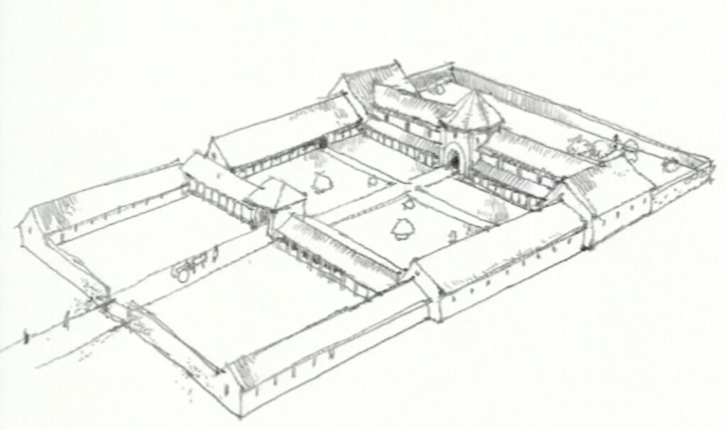
Time Team concluded that the Turkdean Roman Villa had been built by a wealthy Romano-British family of the local Dubonni tribe in about 100-200A.D. and that it was possibly also the location of some proto-industrial activity, perhaps the manufacture of metalware. The abundance of coins found from Valentinian’s reign (364-378A.D.) and relative scarcity of coins from the reign of Theodosius (388-402A.D) suggest that the villa may have been abandoned sometime around or just prior to the date at which Flavius Claudius Constantinus (subsequently Constantine III) withdrew Roman forces from Britain in 407A.D., although some of the pottery and quartz finds at the site suggest that the villa may have continued to be used by post-Roman occupants in to Saxon times.
A very detailed but accessible report on the findings of the Turkdean dig was written up by Neil Holbrook for The Roman Society in 2004 and published with the help of a grant from Time Team (“Turkdean Roman Villa, Gloucestershire.” Archaeological Investigations 1997-8’, Britannia 35, 39-76.)
Saxon Times
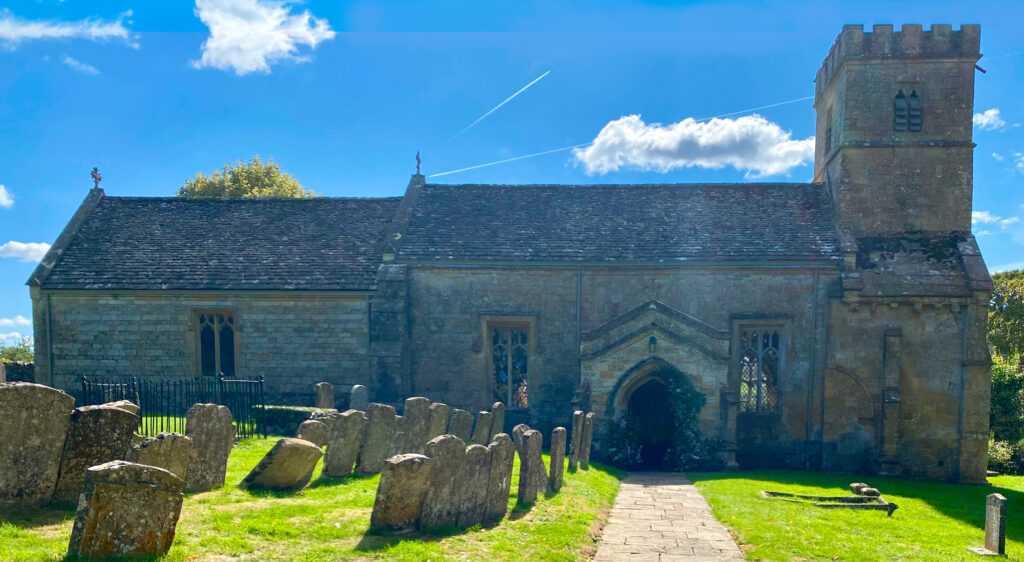
Signs of Turkdean’s existence and occupancy between the Roman withdrawal and the Norman arrival are now few and far between, but the current Norman-origin church might have been built on the site of a previous Saxon foundation, although evidence of this is scant.
However, in the days of Edward the Confessor (1042-1066), the village consisted of two manorial estates: ‘Upper Dean’ and ‘Lower Dean.’ Saxon holders of the Turkdean manorial estates at around this time included Osgot, Siward and Goisfrid.
Village Name
The village’s name has been the subject of some debate over the years, but it seems likeliest that it derived in the pre-Norman period, either from the ancient British, (ie Welsh) word ‘Twrch’, meaning ‘boar’ (most famously the magical boar chased by King Arthur was the “Twrch Trwyth”) and the Saxon word ‘dene’ meaning ‘valley’, or from the stream that flows from Hazleton to Turkdean which was referred to as the “Turce.” However, as the stream name which was only ever locally recognised seems to have itself derived from the prior naming of the village we prefer the derivation from the Valley of the Boars, although the four-legged variant of boars have long since disappeared.
A third village naming theory, given perhaps unjustified weight by it being noted in the Church, is that the village’s name might derive from the family name of putative Norman residents, the ‘La Torque’ family. This sounds romantic, but sadly there is no remaining evidence of the La Torque family’s existence whereas the Doomsday records of Robert d’Oilly and William Leuric’s lordships (discussed below) are easily evidenced, so we tend towards the Welsh/Saxon “Valley of the Boars” interpretation.
Norman Cataloguing
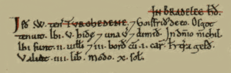
In 1086 the Doomsday Book listed Turkdean, then ‘Turchedene’, in the Hundred of Bradley. The Upper Turkdean manorial estate had been enfeoffed to Robert d’Oilly (alternatively d’Oilgi, or d’Oyly) who fought with William at Hastings and had been appointed Constable of Oxford and given significant estates across Buckinghamshire, Oxfordshire and Gloucestershire by his grateful sovereign, standing as feudal Lord or Tenant-in-Chief directly from the Crown in some 93 manorial estates, including Rissington and Naunton locally, as well as Upper Turkdean.

In Bradlee Hundred the same Robert holds Turchedene.
There are 5 hides and 20 virgates paying geld.
Siward held it.
In demesne are 4 ploughs and 12 villans with 6 ploughs.
There are 4 slaves and 4 female slaves.
It was worth 6l, now 5l.
Hide = Saxon measure of land capable of being cultivated by a single ploughman, varying in size according to the terrain between 60-180acres, but standardised by the Normans at 120acres.
Virgate (or yardland) = a quarter of a Hide, or 30acres.
Geld = Tax levied from time to time at a number of pence per hide.
Demesne = Land in control of feudal lord.
Plough = A plough and 8-oxen plough team.
Villan = A tenant, holding a yardland.
Slave = An individual owing service to another and therefore unable to move or sell their land, or change employment.
Meanwhile, at the bottom of the hill the considerably smaller Lower Dean estate which had been held by Osgod, had been enfeoffed after the Conquest to William Leofric. Considerably smaller than the Upper Dean manor, Lower Dean consisted of just five households and although it had been worth 4l to its Lord in 1066, its value had declined to just 10s (ie 50p) by 1088.
Leofric was a significant landowner, with estates at Hailes, Leckhampton, Shipton Oliffe and Whittington in Gloucestershire as well as other lands in Berkshire and Essex, all of which he seems to have inherited from Asgot (or Osgod) of Hailes. Leofric seems to have been of a mixed Saxon-Norman family background and was probably Asgot’s son.
Similarly, up the hill at Upper Dean, Robert d’Oilly seems to have married the Saxon heiress Ealdgyth daughter of Wigod of Wallingford. So the pattern of mixed Saxon and Norman manorial ownership in the late 11th century and complicated overlaps between estates seems to have been well represented at Turkdean. (See Ann Williams learned study of “A Vice-Comital Family in Pre-Conquest Warwickshire” contained in the Proceedings of the Battle Conference of 1988 if this piques your interest!)
At the time of Doomsday the Hundred of Bradley included the manors of Northleach, Farmington (then ‘Thormarton’), Stowell, Upper Coberley, Compton (Abdale), Hampnett, Hazleton, Yanworth, Salperton, Winson, Coln Rogers and, of course, Turkdean – taken together assessed at 94 hides (ie 11,280 acres.)
Thus, Turkdean was the Northerly outpost of the Hundred, while the adjacent villages of Notgrove and Aston (now Cold Aston) were assessed as part of the Hundred of Wacrescumbe. However, by 1220 the constituent parts of the smaller Wacrescumbe Hundred had been incorporated into an enlarged Bradley Hundred.
Although Northleach would have been the largest component of the Hundred throughout this period the official meeting place at ‘Bradley’, the administrative seat for the Hundred, seems to have been at the Stowell crossroads where the Fosse Way met an ancient ‘Salt Way.’ However, all signs of ‘Bradley’ itself have now disappeared.
Landscape and Cultivation
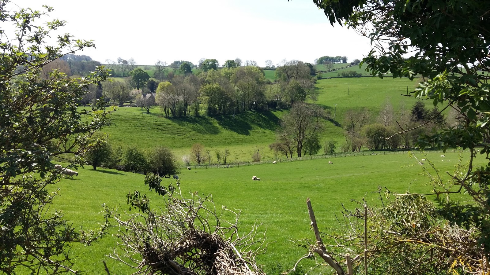
The village of Turkdean sits at the centre of a parish of about 2,178 acres defined by the deep valley to the West and the Roman Fosse Way to the East. The siting of a Roman settlement seems to have been determined by the natural springs in the North of the parish on the East side of this valley.
Before Parliamentary Inclosure in 1792/3 (32 Geo. 3 c.21)Turkdean’s wolds consisted of large open fields, with water meadows in the valley bottoms and precious little woodland. Practically all this land was cultivated under the Saxon and subsequent Norman systems of tenantry until the Black Death of 1348-50. The latter half of the 14th century then witnessed a decline of about 30% in the local population which led to a widespread reduction in cultivation and economic activity.
The area revived from the nadir of the Black Death through the introduction of more intensive sheep-raising, for which the region became famed and prosperous through the later Middle Ages. However, this sheep culture still utilised the open field system. From the late 14th century until the early 16th century woolmen based in Northleach collected the wool from Turkdean for sale to London merchants and the agents of European wool buyers, whose appreciation of the quality of Cotswold wool percolated into significantly increased prosperity both for the Northleach merchants and for the sheep farmers of the surrounding parishes.
This pattern of economic activity continued even as the wool trade declined in significance through the 16th and 17th centuries, leaving a sheep tradition which continued even after Inclosure changed the landscape with the construction of the Cotswold stone walls that are now such an emblematic feature of the area. After Inclosure, however, the significance of cash crops became an ever more important part of the agricultural economy with wheat, barley and oats being supplemented in the modern era with subsidy-dependent crops including oil seed rape and linseed.
Population
The population of Turkdean has ebbed and flowed across the centuries. Through Saxon and Norman times the population of about 40 was split between 20 households in Upper Turkdean and 5 households at Lower Dean and this grew very slowly through the 12th, 13th and 14th centuries so that by 1382 – even in the midst of the impact of the Black Death – the village’s population had grown to 53.
The subsistence level of the community remained in the 40-60 inhabitants range through the later Middle Ages as the local economy moved over to sheep. In 1551 the population still stood at 63, but had expanded to 84 in 1603 and to 120 by 1710. Numbers remained stable through the 18th century, recorded at 113 in 1775, but then, like so much of England, entered a period of accelerated growth in the early 19th century: the population of 143 recorded in the 1801 census had grown to 228 in the 1821 census and to an astonishing 447 in 1861.
From this high watermark in 1861 however, a savage outflow set in as the effect of agricultural depression and the transfer to industry and urban living saw the population halved over the following 30 years and then falling again to just 145 by the time of the 1901 census.
This decline continued at a slower pace through the 20th century, with the population hitting 100 in 1991 and hovering now at about 50-60 regularly resident inhabitants.
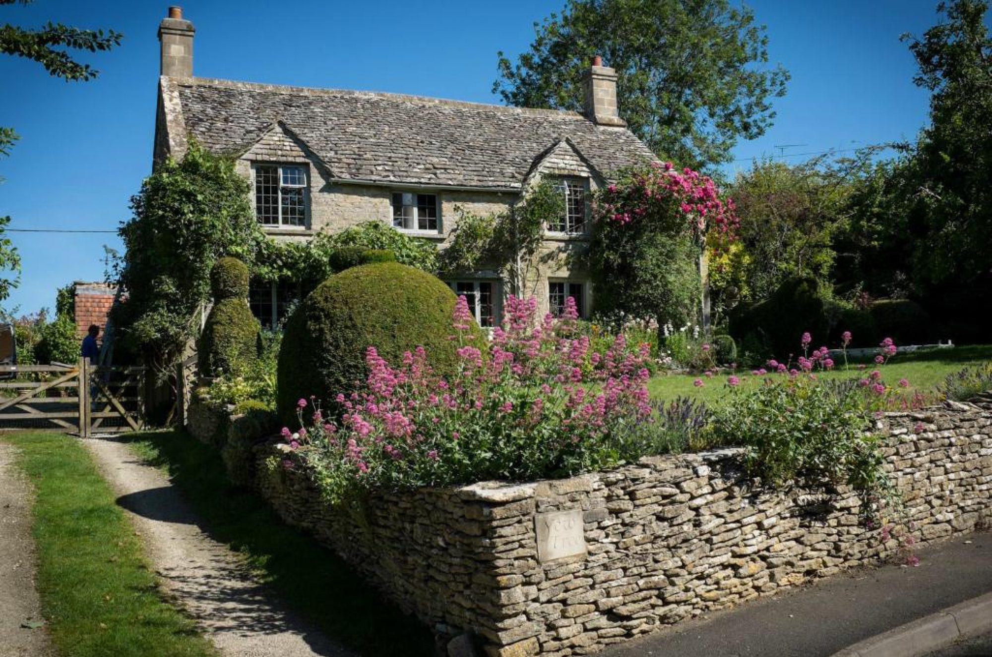
This demographic history has defined the village’s architecture. Many of the dwellings now in occupation (including Yew Tree Cottage) represent either the amalgamation of a number of older, smaller buildings, or have been constructed, enlarged or repaired with the materials from older buildings that fell into disrepair in the late 19th and early 20th centuries.
Other clear signs of the village’s previous size exist in the Church and, most obviously, the School – which was opened in 1874 (with 34 pupils.) The school remained open until 1950, when it became impossible to find a cook to produce lunch, although there were still 13 pupils even in its last year. The school building has now been converted in to a cottage although its previous usage is made clear by the small bell niche and the long side windows left over from its classroom use.
All Saints Church, Turkdean: Church and Parish
The history of the village’s church has outgrown this page and now enjoys a page on the church’s own website.
Upper Dean Manor
Robert d’Oilly’s Doomsday ownership linked Turkdean, alongside Rissington and Naunton, with the ‘honour’ of Wallingford and through this attachment subsequently with Ewelme, but the manor lands had passed to the Bassets before moving on to the Paulton family who retained it through the 14th century until it was acquired by the college of Westbury-on-Trymm sometime before 1509. Confiscated from the college at Dissolution, the manor was then granted to Sir Ralph Sadler, later Chancellor of the Duchy of Lancaster, in 1544. However, ownership passed to the Baynstree (‘Bannister’) family in 1586 when reconstruction of the Manor house was begun.
The Bannisters remained owners of the Turkdean manor through the 17th century and were among the longer-lasting families to own the estate, but they sold their Turkdean and Hazleton lands to the Waller family (from Beaconsfield) in 1725 who also acquired land in Farmington which they retained when they sold their Turkdean land to the Willan family in 1799.
The manor estate was basically reassembled under the ownership of engineer and artist W.A. Rixon (William Augustus), who bought much of Turkdean between 1902 and 1912 and who served as High Sheriff of Gloucestershire in 1914/’15. It was in 1905, under Rixon’s ownership, that the manor house was upgraded from the farmhouse it had remained through successive ownerships into a country house.
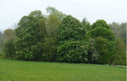
A round copse to the East of Turkdean Manor was planted and named the Bolton Ring in honour of WA Rixon’s wife, Lady Julia Bolton.
After Rixon’s death in 1948 the manor house and its estate were separated, with the land then farmed by Geoffrey Milne until 1958 when a large portion of the land was taken on by the Mustoe family through Wilf and his children Martin and Malcolm, who then sold the Manor Farm estate to Steve Winwood in 2012, thus uniting it with the Lower Dean Manor estate.
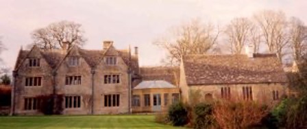
Grade II-listed Turkdean Manor itself passed separately after the Rixons to successive owners in the later 20th century including the Sangsters and the Macleods until Peter and Esther-Marie Smedvig acquired the house in 1997, subsequently upgrading the house significantly and remodelling the complex plan of linked ranges.
Lower Dean Manor
The Doomsday Book reveals that the Lower Dean estate at ‘Turchedene’ had been held by Osgot before the Conquest, but had been enfeoffed to William Leofric by 1086. Considerably smaller than the Upper Dean manor, Lower Dean consisted of just five households and although it had been worth 4l to its Lord in 1066, its value had declined to just 10s (ie 50p) by 1088.
At Doomsday William Leofric’s fiefdom included land at Hailes, Leckhampton, Shipton Oliffe and Whittington in Gloucestershire as well as other lands in Berkshire and Essex all of which he seems to have inherited from Asgot (or Osgod) of Hailes. This feudal lord seems to have been of a mixed Saxon-Norman family background and was probably Asgot’s son. Similarly, up the hill at Upper Dean, Robert d’Oilly seems to have married the Saxon heiress Ealdgyth daughter of Wigod of Wallingford. So the pattern of mixed Saxon and Norman manorial ownership in the late 11th century and complicated overlaps between estates seems to have been well represented at Turkdean. (See Ann Williams learned study of “A Vice-Comital Family in Pre-Conquest Warwickshire” contained in the Proceedings of the Battle Conference of 1988 if this piques your interest!)
However, by 1165 the Lower Dean estate had passed to Llanthony Priory (which at this time had moved to Hempstead just outside the city walls of Gloucester from its original foundation in Monmouthshire, thus Llanthony Secunda.) Llanthony added substantial lands in nearby Aylworth to their holding in 1291 and continued in ownership of the estate until Dissolution. Subsequently, in 1543, the Lower Dean manor was granted to Richard Andrews and Nicholas Temple in two parts, but they quickly sold both parts to the Priory’s previous tenant, William Walter.
The Walters did not retain the Lower Dean estate for long before selling it to the St Johns of Bletso, who owned the estate only briefly from 1575 to 1599. From the St Johns the estate passed to the Spencers, then to the Comptons by marriage and to the Duttons of nearby Sherborne by sale in 1613. After brief ownerships by Robert Brereton and John Rich the bulk of the estate came in to the ownership of John Coxwell in 1665, although the Duttons had retained some of the more southerly lands, known as ‘Leygore’, when they sold the manor. The Coxwells, subsequently by marriage the Nelthorpes, then held Lower Dean manor for over a century until selling it to the Wallers in about 1790, thus uniting the ownership of both Turkdean and Lower Dean manors. However, after passing to the Willans in 1799, following Thomas Willan’s death in 1828 the Lower Dean manor passed to the Taylers who remained in possession until 1903, adding a substantial rear wing to make the house something more than the farmhouse that they had acquired in 1828.
The Lower Dean estate was also acquired by Rixon in 1905 and he made further improvements to the house which was then sold with the bulk of the land by Rixon’s heirs to Geoffrey Milne in 1948. In 1968 the Grade II* listed 16th century Lower Dean Manor house and a portion of the former Lower Dean estate were purchased by the musician Steve Winwood who remains the owner to this day and who acquired the land of the Turkdean Manor estate when it was sold by the Mustoe family in 2012, thus uniting lands that had been held in separate manorial estates for the last 1,000 years.
Leygore
When John Dutton sold the bulk of the Lower Dean estate to Robert Brereton in 1648 he retained around 350 acres of land in the South of the parish which was kept by the Duttons’ Sherborne estate and let to tenant farmers until 1813 when they sold this block to the Willan family which had bought the Turkdean lands from the Wallers in 1799. It was under the ownership of the Sherborne estate that the original Leygore farmhouse was built in 1797. So in 1813 the Leygore land, which historically had been part of the Lower Dean estate, became part of the more northerly Turkdean estate.
However, the Leygore land was then sold away from the Sherborne estate in 1831 to the Hewer family and after they sustained significant losses during the agricultural depression of the 1880s Leygore was sold again, in 1900, to Arthur Edmund Moss, son of the brewer and Winchester MP Richard Moss , who had married Norah Beale Brown, whose family owned the adjoining Salperton Estate and for whom Leygore must have seemed very close to home.
Moss substantially extended and upgraded the Leygore farmhouse into a country house in the 17th century style and then served as High Sheriff of Gloucestershire in 1909/’10. Following Moss’s death in 1943 Leygore was sold by his only daughter, Judith Main, to Richard and Charm Fleming (Richard was a scion of the Scottish banking family and Ian Fleming’s younger brother.) The Flemings acquired further land for Leygore from the church estates of Rectory Farm in the 1960s and it is now Richard and Charm’s youngest son, author Fergus Fleming who owns Leygore today (and is now Chairman of the Parish Meeting, poor chap!)
Rectory Farm
The Church and its lands in the parish were held by Osney Abbey from the 12th century until the time of the Dissolution, when they were granted to the Dean and Chapter of Christ Church. The lease of the Rectory Farm estate was sold to the Wallers in 1790 who thus united the lands of the Turkdean and Lower Dean estates with Leygore and Rectory Farm and their Farmington estate. This lease passed with the other lands to the Willans in 1799, but on Thomas Willan’s death in 1828 the lease was unsellable and it remained in the hands of the Willans’ heirs until the lease was extinguished in 1880. After some years during which these lands were let from year to year, Christ Church sold the freehold of the Rectory Farm lands to W.A. Rixon in 1911, thus reuniting Rectory Farm with the Turkdean and Lower Dean estates once again. However, following Rixon’s death in 1948 the land and farmhouse were sold to Geoffrey Milne and subsequently passed to the Johnsons and then in to the ownership of Peter & Jo England from 1961 until 1968 when the present owner, Giles Daniels, purchased the farmhouse and some of the former Rectory lands.
Mixing the Estates
Thus from the two original manorial estates of Turkdean, four land blocks emerged. The houses that formed the centres of these two manorial estates no longer farm the traditional estate lands with which they were historically associated, but have been repeatedly transferred between the various estates.
Having travelled separate routes for most of the last millennium, the lands of the two manors of Turkdean were briefly united by the Waller family along with their Farmington possessions and then with the Church lands in the parish by the Willan family for a brief period in the early nineteenth century. These lands were brought back together once again by engineer and artist W.A. Rixon in the first half of the twentieth century. However, since Steve Winwood’s purchase of the Manor Farm lands from the Mustoes in 2012 the lands of the Turkdean Manor estate have mostly been brought under the ownership of Lower Dean Manor. Further confusions will no doubt occur in the future.
The village otherwise consists of a number of mostly 17th century cottages and barns. Many of these were gradually consolidated and enlarged in the years after the mid-19th century, as the population of the village steadily declined – allowing the demolition of many of the older, smaller cottages and the improvement of the remaining buildings.
Turkdean in Film
Vying with Turkdean’s appearance on TimeTeam (and perhaps with a larger audience) comes Turkdean’s mention in Spielberg’s “Raiders of the Lost Ark.”

Indiana Jones says to his students: “Let’s get back to Turkdean Barrow near Hazleton. It contains a central passage and three chambers, or cists…” Here’s the clip on YouTube (slightly dodgy pronunciation of Hazleton, but fair enough Indy!)
How on Earth this got in to Lawrence Kasdan’s script is a mystery, but the reference seems most likely to be an amalgamation of Notgrove Long Barrow, originally excavated in 1881, but more recently infilled to prevent vandalism, the now-lost long barrow near Leygore that seems to have been accidentally ploughed up and the two neolithic barrows at Hazleton that were excavated in 1979-82. Fame indeed.
Further Reading
Verey & Brooks (eds.): Pevsner – Gloucestershire 1: The Cotswolds
This extract is taken from Pevsner’s “Gloucestershire 1: The Cotswolds” revised by the late and lamented David Verey and Alan Brooks and published by Yale and Penguin on behalf of the Buildings Books Trust. This details the architectural features of the Church as well as briefly mentioning subsequent domestic buildings including Turkdean Manor and Rectory Farm.
Kingsley: Country Houses of Gloucestershire
Brief descriptions of Turkdean Manor, Lower Dean Manor and Leygore Manor are contained in Nicholas Kingsley’s masterful three-volume dictionary of the Country Houses of Gloucestershire, published in the English Country House series by Phillimore & Co. The Country Houses of Gloucestershire
Vol. 1: 1500-1660 – Turkdean Manor and Lower Dean Manor
Vol. 2: 1660-1830
Vol.3: 1830-2000 – Leygore
But we have a PDF of the extracts about the three Turkdean houses included in these volumes.
Herbert (ed.): History of the County of Gloucester
Volume IX: Bradley Hundred – The Northleach Area
The grand-daddy of all local history surveys is, of course, the Victoria County History series, now published by Boydell & Brewer. The Northleach volume, edited by Nick Herbert, covers Turkdean and all the adjacent parishes within the Bradley Hundred and John Jurica, wrote a fine section on Turkdean the full text of which is now available through the British History Online website.
Clarke: History of Turkdean
Finally, an altogether chattier approach was taken by Turkdean resident John Clarke, in his 1984 history of the parish based on local reminiscence and reportage. We have a PDF of this nicely anecdotal and personal article that fills in a few of the gaps in the more scholarly efforts. It was, it seems, his only foray into historical research, but rather fun.